
Manual Table Of Contents
- Design Philosophy
- Quick Start
- Location Details
- Settings
- Components
- Additional Information
- Advanced
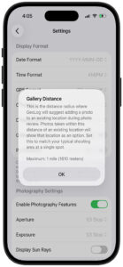
In photography, 500m (over 1,600 ft) is a massive distance. In a city, that’s about 5-6 blocks; in nature, it could be the difference between being on a mountain peak versus at the trailhead.
Recommended Default: 75 Meters (250 Feet)
I suggest a default of 75 meters ( feet).
This is slightly shorter than a standard soccer field (), and here is why it works for photographers:
- The “Same Composition” Rule: Typically, if a photographer moves more than 75m, the relationship between their foreground and background changes so much that it is technically a “different shot” or a different “vantage point.”
- Urban Accuracy: In a city, 75m usually ensures you aren’t accidentally tagging a photo to a gallery for a building on the next block over.
- GPS Drift Buffer: Most modern smartphones have a GPS accuracy of about 5–10m. A 75m radius is large enough to absorb “GPS jump” so the app doesn’t think you’ve left the location, but small enough to remain relevant.
Proximity Tiers for GeoLog
If you want to offer “Presets” in your settings, here is how you might label them to make sense to a photographer:
| Setting Name | Radius (Meters) | Use Case / Logic |
|---|---|---|
| Tight | 25m | Architecture/Street: You are standing at the exact same doorway or monument. |
| Standard (Default) | 75m | “The Soccer Field”: You are in the same general area or park clearing. |
| Landscape | 150m | Vast Vistas: You are scouting a large ridge or a beach where “The Beach” is one gallery. |
Visualizing the Radius
To help your users understand these distances in the settings menu, you can use these real-world comparisons:
- 25m: Roughly the length of a swimming pool.
- 75m: Roughly the distance of a short soccer field or the height of a 20-story building.
- 150m: Roughly 1.5 soccer fields or the length of a large cruise ship.
Implementation Tip
Since you mentioned 500m was suggesting “irrelevant locations,” you might also want to implement a Heading (Compass) Check.
If a photographer is at the same GPS point but facing North in one photo and South in another, they might be looking at two entirely different subjects (e.g., a mountain vs. a lake). You could suggest the same gallery only if the distance is < 75m AND the **compass heading is within **.